
Home
Visiting
- Where We Are
- Timetable and Fares
- History of the Line
- The Journey
- Warcop Emporium
- Buffer Stop Refreshments
- Model Railways
- Contact Us
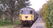
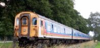
Rolling Stock
Helping the Railway
Miscellany
- GB2EVR and ROTA
- Emporium on the Road
- The Railway from Above
- EVR on the Radio
- The Cumbrian Boat Train
Galleries
Links
Description of the journey (text only) with a brief history of the line.
Description of the journey with some illustrative pictures (PDF version of the document below)
Eden Valley Railway
A Description of the journey
This is a description of what can be seen from the left-hand window facing the direction of travel on the current passenger service.
The mile-posts are on the left-hand (southern) side going away from Warcop. The remaining original ones were in a poor condition and have been replaced by modern replicas. The distances are miles (and quarter-miles) from what was Kirkby Stephen West Junction. The mileage at Warcop Station is between 5½ and 5¾ miles, the latter post being just beyond the end of the platform.

We then pass the army camp. It was the presence of the army camp and ranges at Warcop which led to the survival of the line from Appleby to Warcop after the rest of the Eden Valley Railway had closed. Through the trees you can see the camp’s climbing tower. At the far end of the accommodation area is a patch of rough ground which used to be a rifle range – it has also been used for clay pigeon shooting.
Just past here the Ordnance Survey map shows an “ancient earthwork” close to the railway which here is going very slightly uphill. The hill to the left is called Vicarage Bank.
Another footpath crosses the railway here and heads up Vicarage Bank after crossing a small drainage ditch on a little footbridge. This ditch shortly joins a stream called Cringle Beck which comes under the railway, which is now going gently downhill.

On a clear day the Lake District fells can be seen on the horizon to the left from this point onwards and looking back slightly the Mallerstang Ridge and Wild Boar Fell can be seen. Once over the bridge the line descends gently again, past a small field where goats can often be seen and then past marshy ground known as Sandford Mire.
At the end of this straight section of line is a small wooded area which has grown around an old gravel pit, and it is at the far end of this wood that the train terminates, near a platelayers’ hut.

The train reverses here, so the ‘left-hand side facing direction of travel’ is now at the opposite side of the carriage!
From the left hand side of the train at Southfields the A66 can be seen and beyond the Warcop Fells are prominent, as are some of the more northerly Pennine fells.
As the train, now heading uphill, departs and rounds a curve there is a small and damp wooded area. Shortly after this there is a curious section of fencing of approximately one wagon’s length which is further from the line than the rest of the fence.

Once over the road bridge notice the group of farm buildings. These are Dike Nook, now the base of an agricultural engineering firm. Just behind the buildings the A66 is at this point following the course of a roman road, and nearby are the remains of a Roman temporary marching camp.
As the train enters Wildboar cutting the remains of another platelayers’ hut can be seen. The bulk of Wildboar Hill is apparent and some of the effects of the 2013 landslip can be seen on the hillside, below the fence.
We then come to the footpath crossing again. On this side the path goes to the A66 to buildings which are now known as Wheat Sheaf Farm, but which on an 1863 map were shown as Wheat Sheaf Inn, presumably a coaching inn.
The next footpath to cross the railway, at the Warcop end of the army camp, leads to the A66 close to Walk Mill. It used to continue up the fells beyond but this is now an army range with very little public access. The range opened in 1942 and now covers 24,000 acres. It is used for all weapons, from small arms to heavy artillery.
We then pass the Army sports field and helicopter landing area. Part-way up the fells can be seen an army command post on stilts, used for controlling activity on the ranges.
We then cross over to road to Warcop again and return to the platform. The old Station House is now in private hands – please respect the privacy of the owners.

Its form is a short round structure with a taller and thinner structure protruding, resembling a small mine. It was built by John Metcalfe Carleton in 1779 when he took ownership of Helbeck Hall above Brough and is a folly which was used mainly for picnic parties with fine views over the Eden Valley.
First version written by John Tillotson
Second version with amendments and additions by Caroline Mitchell